
Skip to content
Atlas Anatolia
Dig
NewsIce Age teeth in Sulawesi push betel-nut use back as far as 25,000 yearsRoman mosaic and Eros head uncovered in the basilica at Pompeiopolis, Kastamonu
Excavated foundations and stone sanctuary pylons of the Small Aten Temple at Tell el-Amarna, Egypt

Wikimedia Commons / CC BY-SA 3.0

Country Record

Oldest City in Egypt

CityFeatured

Amarna

Seyfi Cem Baskin

Tell el-Amarna / أخناتون / تل العمارنة1346 BCE – 1332 BCE

Short-lived capital city of 18th-Dynasty Egypt founded c. 1346 BCE by Pharaoh Akhenaten to serve as the exclusive sanctuary of the Aten sun disk. Abandoned shortly after Akhenaten’s death, the virgin desert site yielded the diplomatic Amarna Letters archive and the royal workshop where the iconic bust of Nefertiti was sculpted.

211
Interest 62

Location

Minya Governorate · Egypt

27.65°N · 30.90°E · Africa

Foundation Date

c. 1346 BCE (Year 5 of Akhenaten)

Original Ancient Name

Akhetaten ("Horizon of the Aten")

Diplomatic Archive

382 Amarna Letters in Akkadian cuneiform

Artistic Milestone

Bust of Nefertiti found in Thutmose’s workshop (1912)

Abandonment

c. 1332 BCE under Tutankhamun

“Amarna provides the most complete and unaltered snapshot of an ancient Egyptian urban metropolis in existence, frozen in time because it was founded on virgin desert and abandoned within two decades.”

Location

Overview

Amarna (ancient Akhetaten, meaning "Horizon of the Aten") was established in the fifth year of Pharaoh Akhenaten’s reign (c. 1346 BCE) on a virgin crescent of desert bounded by eastern cliffs along the east bank of the Nile in Middle Egypt. Deliberately positioned on land unassociated with any pre-existing deity or priesthood, the city was conceived as the physical and spiritual headquarters of Akhenaten’s radical religious revolution, which demoted the traditional polytheistic pantheon headed by Amun-Ra of Thebes in favour of the sole veneration of the Aten, represented as a radiant sun disk whose descending rays terminated in blessing human hands.

Fourteen monumental Boundary Stelae carved into the surrounding cliffs demarcated the sacred municipal limits of Akhetaten, accompanied by royal oaths that the king and his divine family would never expand beyond these borders. Within this arena arose an entirely new open-air urban layout: the Great Aten Temple (Per-Aten), measuring nearly 760 by 270 meters, discarded traditional dark roofed sanctuaries for vast unroofed courtyards crammed with hundreds of whitewashed stone offering tables designed to receive direct solar illumination. Adjoining the temple lay the Great Royal Palace, the King's House connected by a covered brick bridge across the Royal Road, and expansive administrative quarters including the "Bureau of Correspondence of Pharaoh," where local villagers uncovered the Amarna Letters in 1887—nearly 400 baked clay tablets inscribed in Akkadian cuneiform recording diplomatic relations between Egypt and Babylon, Assyria, Mitanni, and Canaanite client city-states.
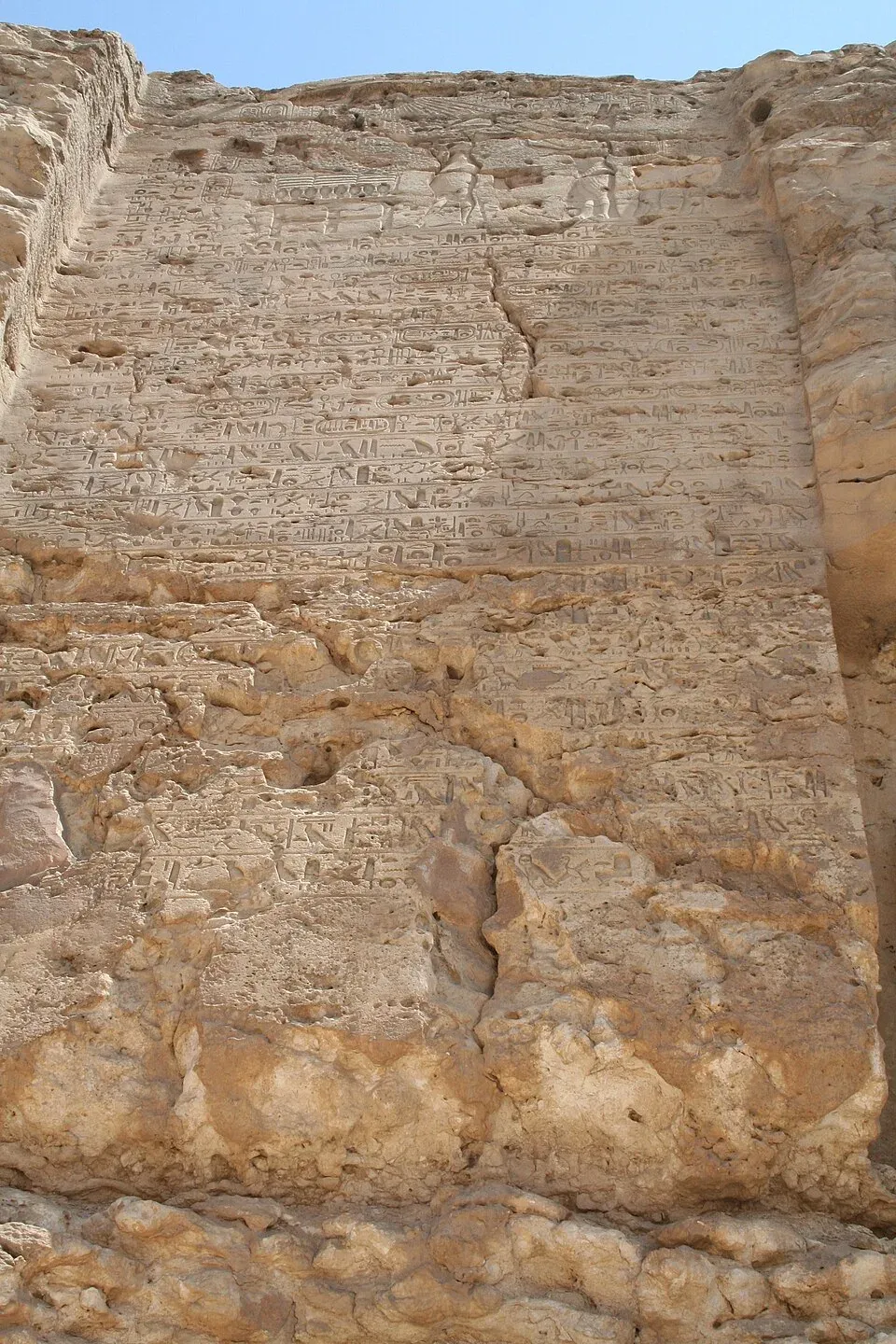
Amarna boundary stela U 01
Amarna boundary stela U 01 | Einsamer Schütze (CC BY-SA 3.0)
"Thou appearest beautifully on the horizon of heaven, thou living Aten, the beginning of life... How manifold are thy works, they are hidden from the face of men, O sole God, like whom there is no other!"
— The Great Hymn to the Aten, inscribed in the Tomb of Ay at Amarna (c. 1345 BCE; Lichtheim, Ancient Egyptian Literature)

In the southern suburbs stood private residential villas, walled gardens, and artisan studios, most notably the courtyard workshop of the Chief Sculptor Thutmose (House P47.1-3). Excavated by the German Oriental Society under Ludwig Borchardt in December 1912, Thutmose’s studio yielded a treasure trove of sculptor’s models and master portraits, including the world-renowned painted stucco-coated limestone bust of Great Royal Wife Nefertiti, along with lifelike plaster casts that captured intimate family scenes and idiosyncratic, naturalistic bodily proportions characteristic of Amarna art. Eastward across the desert plain, the Royal Wadi concealed Akhenaten’s rock-cut multi-chamber tomb, while the Northern and Southern Tombs held the elaborate sepulchres of royal courtiers inscribed with the Great Hymn to the Aten.
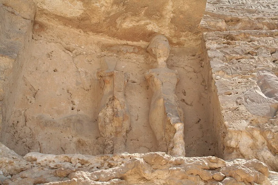
Amarna boundary stela U 02
Amarna boundary stela U 02 | Einsamer Schütze (CC BY-SA 3.0)

Following Akhenaten's death around 1336–1334 BCE, the Amarna heresy collapsed with astonishing speed. His successor Tutankhaten changed his name to Tutankhamun, abandoned Akhetaten, and returned the court and royal administration to Memphis and Thebes. During the succeeding 19th and 20th Dynasties, particularly under Horemheb and Ramesses II, Akhetaten was systematically dismantled: its stone structures were broken down into portable "talatat" blocks and reused as rubble fill in temples across Hermopolis and Karnak, while the royal names of Akhenaten and his immediate successors were struck from official king lists. Because the city was never reoccupied by subsequent civilizations, its mudbrick street plans, domestic houses, and industrial bakeries remained preserved beneath desert sands for over three millennia, offering modern archaeologists an unparalleled time capsule of 14th-century BCE Bronze Age daily life.
Why It Matters

Amarna provides the most complete and unaltered snapshot of an ancient Egyptian urban metropolis in existence, frozen in time because it was founded on virgin desert and abandoned within two decades. Beyond its unmatched architectural value, the site represents the earliest documented attempt at state-mandated monotheism, the birthplace of the revolutionary naturalism in Amarna period art, and the provenance of the Amarna Letters—the most critical primary archive for understanding late Bronze Age Mediterranean geopolitics and diplomatic balance of power.

Evidence & Interpretation

Distinguishing what is well-established from what remains debated.

Well-Established Facts

2
  • Epigraphic stelae, mudbrick foundation stamps, and boundary inscriptions confirm Akhetaten was founded by Akhenaten on virgin soil as the dedicated cult center of the Aten.
  • Excavations at House P47.1-3 in 1912 confirmed the location of Chief Sculptor Thutmose’s workshop through inscribed ivory horse blinkers and dozens of royal plaster portrait studies.

Scholarly Inferences

1
  • Spatial analysis of domestic compounds indicates that Amarna’s urban population of 20,000–30,000 lived in non-hierarchical residential clusters where high officials and craftspeople shared neighborhood sectors.

Debated Interpretations

1
  • Scholars vigorously debate whether Queen Nefertiti ruled independently as the pharaoh Neferneferuaten following Akhenaten’s death, or if the co-regent was Prince Smenkhkare.

Community Photos

Share your experience

Have you visited this site? Upload your photos to help others discover it.

Related Stories

How to cite this page

Atlas Anatolia. (1346). Amarna. Atlas Anatolia. https://atlasanatolia.com/site/amarna

Content licensed CC BY-SA 4.0 — attribution required when reusing.

Graph

Connections to related sites and stories.

Sources

  • The City of Akhenaten and Nefertiti: Amarna and Its People — Barry Kemp (2012)Link
  • Akhenaten: King of Egypt — Cyril Aldred (1988)Link
  • The Amarna Letters — William L. Moran (1992)Link

Frequently Asked Questions

Where is Amarna located?

Amarna is located in Minya Governorate, Egypt.

How old is Amarna?

Amarna dates to approximately 1346 BCE – 1332 BCE.

Which civilizations are associated with Amarna?

Amarna is associated with the Ancient Egyptian.

Why is Amarna important?

Amarna provides the most complete and unaltered snapshot of an ancient Egyptian urban metropolis in existence, frozen in time because it was founded on virgin desert and abandoned within two decades.

Is Amarna a UNESCO World Heritage Site?

Amarna is not currently inscribed on the UNESCO World Heritage List.