
콘텐츠로 건너뛰기
Atlas Anatolia
디그
뉴스술라웨시 빙하기 치아에서 빈랑 사용 25,000년 전까지 소급카스타모누 폼페이오폴리스 바실리카에서 로마 모자이크와 에로스 두상 발견
Excavated stone walls and spoil of Tel Megiddo overlooking the Jezreel Valley

Wikimedia Commons (CC BY-SA 3.0)

Country Record

Longest Continuously Occupied Site in Israel

정착지유네스코주요

Tel Megiddo

Seyfi Cem Baskin

תל מגידו7000 기원전 – 400 기원전

The multi-layered tell overlooking the Jezreel Valley — Canaanite city, Egyptian stronghold, and Israelite fortress whose Greek name Armageddon entered apocalyptic tradition — ranks first among missing archaeological sites in our EN/DE/TR/ZH Wikipedia pageview audit.

21
관심 68

위치

이스라엘

32.59°N · 35.18°E · 아시아

Strata

20+ occupation levels, Neolithic–Persian

Battle of Megiddo

Thutmose III, c. 1457 BCE

UNESCO

Biblical Tels (2005)

Famous find

Water system, six-chambered gate, “stables”

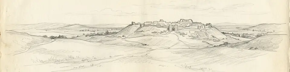
Graphite pencil sketch banner of Tel Megiddo

“Megiddo’s stratigraphy is a laboratory for correlating biblical narratives with Egyptian and Assyrian texts against continuous material layers.”

위치

개요

Tel Megiddo rises about 60 metres above the western Jezreel Valley in northern Israel, controlling the Via Maris pass that funneled traffic between Egypt and Mesopotamia. Excavations by Gottlieb Schumacher (1903–05), the Oriental Institute of Chicago (1925–39), Yigael Yadin, and the Tel Aviv–Pennsylvania consortium since the 1990s have cut more than twenty occupational strata from the Neolithic into the Persian period.

Middle and Late Bronze layers expose massive Canaanite fortifications, the well-known “Gallery 629” water system, and palace compounds tied to Egyptian overlordship — Megiddo is named in Thutmose III’s year-23 campaign records among the coalition defeated at the Battle of Megiddo (c. 1457 BCE). Iron Age rebuilds include six-chambered gates, stables long debated as Solomonic or Omride, and Assyrian destruction horizons after Tiglath-Pileser III.

The New Testament Greek Harmagedōn (“Mount Megiddo”) fixed the site in Christian apocalyptic geography. UNESCO inscribed the “Biblical Tels — Megiddo, Hazor, Beer Sheba” serial property in 2005. Pair with Jericho and Hattusha for contrasting Levantine and Anatolian bronze-age power centres.
중요성

Megiddo’s stratigraphy is a laboratory for correlating biblical narratives with Egyptian and Assyrian texts against continuous material layers. Its water system, gates, and destruction deposits remain reference points for Iron Age Levantine chronology and for how geography produces strategic myth.

증거와 해석

확립된 사실과 논쟁 중인 사항을 구분합니다.

잘 확립된 사실

2
  • Egyptian annals of Thutmose III name Megiddo as the focus of the year-23 Syrian campaign.
  • Ceramic, radiocarbon, and architectural sequences from Chicago and Tel Aviv–Pennsylvania digs fix major Bronze and Iron horizons.

논쟁 중인 해석

1
  • Whether the famous stables and six-chambered gate date to Solomon (10th c. BCE) or the Omride dynasty remains contested.

커뮤니티 사진

당신의 경험을 공유하세요

이 유적지를 방문하셨나요? 다른 탐험가들을 위해 사진을 업로드해 보세요.

관련 이야기

이 페이지 인용 방법

Atlas Anatolia. (7000). Tel Megiddo. Atlas Anatolia. https://atlasanatolia.com/ko/site/megiddo

콘텐츠는 CC BY-SA 4.0 라이선스에 따라 제공됩니다 — 재사용 시 출처 표시가 필요합니다.

그래프

관련 유적지와 스토리로의 연결.

출처

  • The Battles of Armageddon: Megiddo and the Jezreel Valley from the Bronze Age to the Nuclear Age — Cline, Eric H. (2000)
  • The Bible Unearthed — Finkelstein, Israel; Silberman, Neil Asher (2001)
  • UNESCO — Biblical Tels링크

자주 묻는 질문

Tel Megiddo은(는) 어디에 위치해 있나요?

Tel Megiddo은(는) Israel에 위치해 있습니다.

Tel Megiddo의 연대는 언제인가요?

Tel Megiddo의 연대는 대략 7000 기원전 – 400 기원전로 거슬러 올라갑니다.

Tel Megiddo과(와) 관련된 고대 문명은 무엇인가요?

Tel Megiddo은(는) Ancient Egyptian, Canaanite, Israelite 문명과 관련이 있습니다.

Tel Megiddo이(가) 중요한 이유는 무엇인가요?

Megiddo’s stratigraphy is a laboratory for correlating biblical narratives with Egyptian and Assyrian texts against continuous material layers.

Tel Megiddo은(는) 유네스코 세계유산인가요?

예 — Tel Megiddo은(는) 유네스코 세계유산으로 등재되어 있습니다.