
Vai al contenuto
Atlas Anatolia
NotizieIce Age teeth in Sulawesi push betel-nut use back as far as 25,000 yearsRoman mosaic and Eros head uncovered in the basilica at Pompeiopolis, Kastamonu
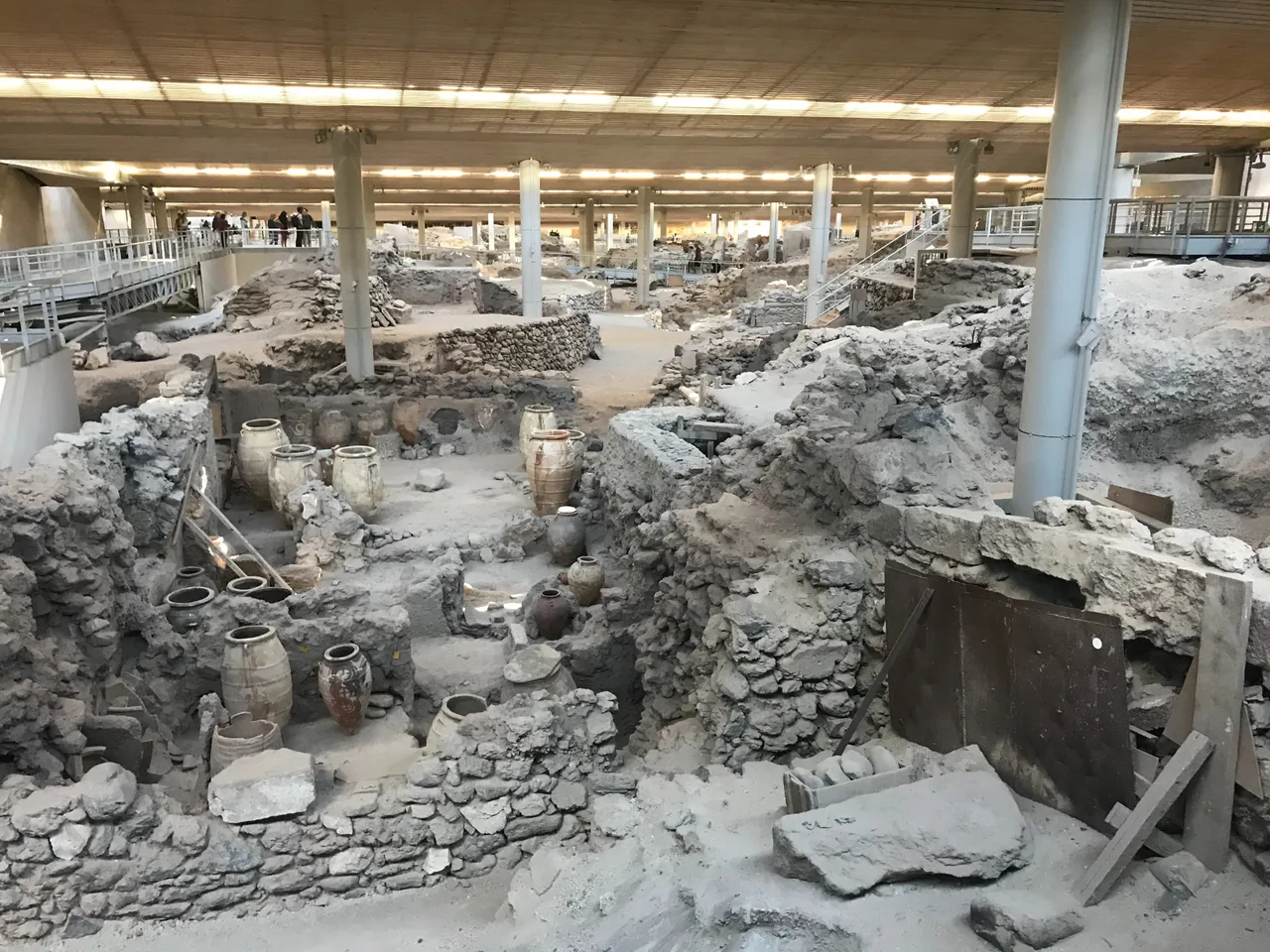
Excavated multi-storey buildings at Akrotiri under the protective roof

Wikimedia Commons

Record nazionale

Oldest Settlement in Greece

InsediamentoIn evidenza

Akrotiri

Seyfi Cem Baskin

Ακρωτήρι3000 a.C. – 1620 a.C.

A Bronze Age Aegean city on Santorini buried by one of the largest volcanic eruptions in human history c. 1600 BCE, preserving multi-storey buildings, vivid frescoes, and stone-paved streets in near-intact condition.

32
Interesse 63

Posizione

Grecia

36.35°N · 25.40°E · Europa

Eruption date (estimated)

c. 1627–1600 BCE (disputed)

VEI (eruption magnitude)

7 — one of the largest Holocene eruptions

Human remains found

None — population evidently evacuated

Building heights

Up to 3 storeys surviving

Frescoes

Extensive polychrome fresco cycles, now in Athens National Museum

Excavation began

1967, by Spyridon Marinatos

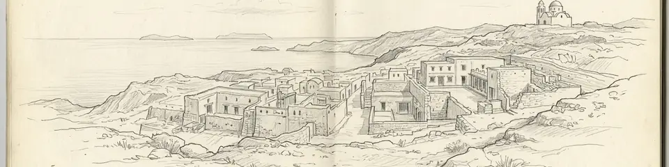
Graphite pencil sketch banner of Akrotiri

Akrotiri reframes what the Bronze Age Aegean looked like.”

Posizione

Panoramica

Akrotiri lies at the southern end of Santorini (ancient Thera), the crescent-shaped caldera island in the southern Aegean. Around 1600–1627 BCE (the exact date is disputed between radiocarbon and ice-core evidence), the island's volcanic system erupted catastrophically — an event with a Volcanic Explosivity Index of 7, comparable to Tambora (1815) and roughly five times the energy of Krakatau (1883). The tephra fallout can be traced across the eastern Mediterranean, Egypt, and the Greenland ice cores. The eruption destroyed Minoan settlements across Thera and, some argue, contributed to the collapse of the Minoan civilization on Crete. Akrotiri itself, excavated by Spyridon Marinatos from 1967, is the best-preserved Bronze Age settlement in the Aegean. The volcanic pumice blanket sealed buildings intact: multi-storey structures survive to their original height, with stone staircases, clay pipes (running water), beds of carbonized grain, pottery in situ on shelves, and most remarkably, fresco cycles of extraordinary quality. The frescoes — depicting fishermen, boxers, antelopes, swallows, a blue flotilla fleet, and detailed landscape paintings — are the most extensive figurative paintings surviving from the Bronze Age world. Crucially, no human remains have been found at Akrotiri, suggesting the population evacuated before the eruption.

Perché è importante

Akrotiri reframes what the Bronze Age Aegean looked like. The frescoes — particularly the Flotilla Fresco, a continuous panoramic painting of a sea voyage between two towns — show a sophisticated urban maritime civilization with detailed knowledge of ships, landscape, and costume. The running water system, piped through clay tubes under pressure, demonstrates a level of hydraulic engineering not seen again in Europe until Roman times. The question of whether Akrotiri's destruction inspired the Atlantis legend — as Plato's Timaeus and Critias describe an island civilization swallowed by the sea — is one of the most persistent debates in popular archaeology, though mainstream scholarship remains skeptical.

Evidenze e interpretazione

Distinguere ciò che è ben consolidato da ciò che rimane dibattuto.

Fatti ben consolidati

3
  • The eruption date is constrained by the Greenland GISP2 ice core, which records a major volcanic layer around 1645–1628 BCE, and by radiocarbon dating of olive branches buried by the tephra, which gives 1627–1600 BCE at 95% confidence.
  • Multi-storey buildings at Akrotiri survive intact under the pumice, including a water supply system consisting of clay pipes with socketed joints running under building floors and streets — the earliest known urban pressurized water system in the Aegean.
  • The complete absence of human skeletal remains and of valuables such as metal objects or jewelry indicates the population evacuated in an orderly manner before the main eruption phase, probably following precursor earthquakes.

Interpretazioni dibattute

2
  • The eruption's role in causing the collapse of Minoan civilization on Crete is actively debated. Minoan Crete continued for at least one to two centuries after the eruption, and the collapse is now attributed to a combination of factors including drought, internal conflict, and Mycenaean encroachment.
  • The identification of Akrotiri's eruption as the inspiration for Plato's Atlantis story (Timaeus, c. 360 BCE) is widely discussed in popular literature but not accepted by most classicists, who view Atlantis as a philosophical device invented by Plato.

Foto della comunità

Condividi la tua esperienza

Hai visitato questo sito? Carica le tue foto per aiutare gli altri a scoprirlo.

Storie correlate

Come citare questa pagina

Atlas Anatolia. (3000). Akrotiri. Atlas Anatolia. https://atlasanatolia.com/it/site/akrotiri

Contenuto con licenza CC BY-SA 4.0 — è richiesta l'attribuzione in caso di riutilizzo.

Grafico

Collegamenti a siti e storie correlati.

Fonti

  • Excavations at Thera I–VIISpyridon Marinatos (1968)
  • The Date of the Minoan Eruption of SantoriniFriedrich et al. (2006)Collegamento

Domande frequenti

Dove si trova Akrotiri?

Akrotiri si trova in Greece.

A quando risale Akrotiri?

Akrotiri risale all'incirca al 3000 a.C. – 1620 a.C..

Quali civiltà sono associate a Akrotiri?

Akrotiri è associato alla civiltà Minoan.

Perché Akrotiri è importante?

Akrotiri reframes what the Bronze Age Aegean looked like.

Akrotiri è un sito Patrimonio Mondiale dell'UNESCO?

Akrotiri non è attualmente iscritto nella lista del Patrimonio Mondiale dell'UNESCO.