
Aller au contenu
Atlas Anatolia
ActualitésIce Age teeth in Sulawesi push betel-nut use back as far as 25,000 yearsRoman mosaic and Eros head uncovered in the basilica at Pompeiopolis, Kastamonu
Roman theatre and Mediterranean shoreline at Caesarea Maritima, Israel

Wikimedia Commons (CC BY-SA 3.0)

Country Record

Known by the Most Names in Israel

CitéEn vedette

Caesarea Maritima

Seyfi Cem Baskin

קיסריה22 av. J.-C. – 1265 apr. J.-C.

Herod the Great’s purpose-built Roman port on the Sharon coast, with the harbour of Sebastos, a theatre, hippodrome, and aqueduct. A 2025 Haifa–Malta photogrammetric survey of the drowned harbour mouth shows two building phases and a channel still deep enough for ships.

31
Intérêt 67

Localisation

Israël

32.50°N · 34.89°E · Asie

Founded

Herod the Great, 22–10/9 BCE, on Straton’s Tower

Harbour

Sebastos — hydraulic pozzolana concrete breakwaters, larger than the Piraeus

Pilate Stone

Latin Tiberieum dedication by Pontius Pilate, found 1961 in the theatre

Capital

Roman Judaea / Syria Palaestina / Palaestina Prima for c. 650 years

2025 survey

Haifa–Malta photogrammetry of the harbour mouth (JMSE 13.5)

Fall

Mamluk capture under Baybars, 1265

“Sebastos is the textbook of Roman harbour engineering in the East — imported pozzolana, open-water caissons, and a client king building a deep-water gate for grain and troops.”

Localisation

Aperçu

Caesarea Maritima occupies the Sharon coast of present-day Israel, between Tel Aviv and Haifa. Herod the Great rebuilt the decayed Hellenistic anchorage of Straton’s Tower between 22 and 10/9 BCE as a marble-faced city named for Augustus, with a temple to Roma and Augustus on a raised platform facing the sea. The harbour — Sebastos, the Greek for Augustus — was the first large-scale use of hydraulic pozzolana concrete in the eastern Mediterranean: volcanic ash shipped from the Bay of Naples, dumped in timber caissons in open water to form breakwaters larger than the Piraeus. Josephus describes the inner basins, towers, and colonnades; underwater archaeology since the 1960s (Avner Raban and successors) has mapped the northern and southern moles, now partly collapsed by earthquake and current.

On land the city became the capital of Roman Judaea after 6 CE, then of Syria Palaestina and Palaestina Prima — a six-century administrative centre. The “Pilate Stone,” a Latin dedication of a Tiberieum by Pontius Pilatus, prefect of Judaea, was found in the theatre in 1961 during the Italian mission directed by Antonio Frova. The apostle Paul was imprisoned here (Acts 23–26). A theatre, a 300 m hippodrome later converted to an amphitheatre, vaulted warehouses, Crusader walls, and the high-level aqueduct from the Carmel springs structure the visitor circuit. The city fell to Baybars in 1265; the ruins are now Caesarea National Park.

"The king overcame nature, and built a haven larger than was the Piraeus, and had docks in it for ships, and towers upon the breakwaters, so that this city should not want a harbour."
— Josephus, Jewish Antiquities 15.331–341, on Herod’s harbour of Sebastos (Whiston trans., public domain)
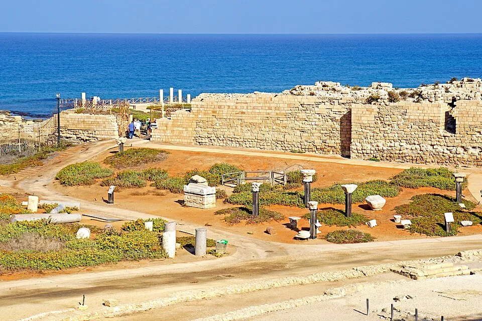
Israel-04800 - Looking Down 32853651473
Israel-04800 - Looking Down 32853651473 | Dennis G. Jarvis (CC BY-SA 2.0)

In 2025 Gil Gambash, Ehud Arkin-Shalev, Emmanuel Nantet (University of Haifa) and John Wood and Timmy Gambin (University of Malta) published the first stage of Caesarea SubMaritima in the Journal of Marine Science and Engineering: diver-based photogrammetry of the harbour entrance (Raban’s areas G and K) produced a high-resolution 3D model. The two sides of the channel use different masonry, which the authors read as an original Herodian build plus a later repair; despite collapse and sedimentation the entrance remains deep and wide enough for vessels, so Sebastos did not die only because the mouth silted shut. The related SHIPs project (from autumn 2023) re-examined the North Caesarea 1 merchantman in the northern bay. Pair the port with Ostia Antica for imperial harbour archaeology, Masada for Herodian building, and Jerash for a comparable eastern Roman city.

The 2018 IAA mosaic of three togate figures under a Byzantine shop — often recycled in travel copy as a “new 2025 find” — belongs to that earlier bridge-rebuild season, not to the SubMaritima survey. The 2025 news is underwater: geometry of the mouth, not a newly unveiled pavement.

Pourquoi c'est important

Sebastos is the textbook of Roman harbour engineering in the East — imported pozzolana, open-water caissons, and a client king building a deep-water gate for grain and troops. The 2025 3D survey revises a simple “earthquake killed the port” story: the entrance still functions as a channel, so decline was piecemeal, basin by basin, not a single night of collapse.

Preuves et interprétation

Distinguer ce qui est bien établi de ce qui reste débattu.

Faits bien établis

3
  • The Pilate Stone’s inscription names Pontius Pilatus as prefect of Judaea and records a Tiberieum; it was excavated in the theatre in 1961 and is among the few contemporary epigraphic attestations of Pilate.
  • Pozzolana in the breakwater concrete matches Campanian sources; timber-caisson construction in open water is documented by Raban’s harbour excavations and by Josephus’s description of Sebastos.
  • The 2025 SubMaritima photogrammetric model shows two masonry styles at the harbour entrance and a channel still dimensioned for shipping despite collapse debris (Gambash et al., JMSE 13.5, 11 May 2025).

Inférences savantes

1
  • Differing architecture on the two sides of the mouth is read as a later renovation rather than a single Herodian design; the repair campaign is not yet dated independently.

Photos de la communauté

Partagez votre expérience

Avez-vous visité ce site ? Téléchargez vos photos pour aider les autres à le découvrir.

Comment citer cette page

Atlas Anatolia. (22). Caesarea Maritima. Atlas Anatolia. https://atlasanatolia.com/fr/site/caesarea-maritima

Contenu sous licence CC BY-SA 4.0 — attribution requise en cas de réutilisation.

Sources

  • Caesarea Maritima: A Retrospective after Two Millennia — Raban, Avner; Holum, Kenneth G. (eds.) (1996)
  • Caesarea SubMaritima: Insights into the Entrance of the Roman Harbour of Sebastos — Gambash, Gil; Arkin-Shalev, Ehud; Wood, John; Nantet, Emmanuel; Gambin, Timmy (2025)Lien
  • Jewish Antiquities 15.331–341 (harbour of Sebastos) — Josephus (94)

Questions fréquentes

Où se trouve Caesarea Maritima ?

Caesarea Maritima est situé à/en Israel.

De quand date Caesarea Maritima ?

Caesarea Maritima remonte approximativement à 22 av. J.-C. – 1265 apr. J.-C..

Quelles civilisations sont associées à Caesarea Maritima ?

Caesarea Maritima est associé à la civilisation Roman, Byzantine, Islamic / Medieval, Judean.

Pourquoi Caesarea Maritima est-il important ?

Sebastos is the textbook of Roman harbour engineering in the East — imported pozzolana, open-water caissons, and a client king building a deep-water gate for grain and troops.

Caesarea Maritima est-il inscrit au patrimoine mondial de l'UNESCO ?

Caesarea Maritima n'est pas actuellement inscrit sur la liste du patrimoine mondial de l'UNESCO.