
Carte interactive du monde antique
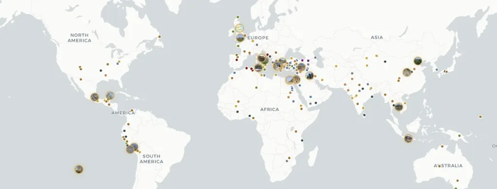
Atlas Anatolia est une carte interactive gratuite de 303 sites archéologiques anciens sur tous les continents habités — des abris paléolithiques aux forteresses du début de l'époque moderne.
Filtrez par continent, époque, civilisation et type de site. Chaque dossier associe un récit encyclopédique à des évaluations de confiance des preuves (confirmé, déduit, débattu, reconstitution), des chronologies de fouilles et des sources savantes. Le contenu est sous licence CC BY-SA 4.0 — libre de citation avec attribution. Disponible en anglais, turc, allemand, chinois et espagnol — aucun compte requis. Pour les identifiants de lieux de type gazetteer, voir Pleiades ; pour les planches chronologiques d'atlas, voir TimeMaps — Atlas Anatolia se concentre sur des dossiers de sites évalués selon les preuves sur une carte interactive MapLibre.
Comment Atlas se compare
Comparaison de fonctionnalités pour les lecteurs choisissant une carte de recherche — non un classement de l'érudition.
| Fonctionnalité | Atlas Anatolia | Wikipedia | Pleiades | TimeMaps |
|---|---|---|---|---|
| Carte mondiale interactive | Oui | Partiel | Oui | Oui |
| Évaluations de confiance des preuves | Oui | Non | Non | Non |
| Comparaison de sites côte à côte | Oui | Non | Partiel | Non |
| Consultation gratuite | Oui | Oui | Oui | Partiel |
Outils de l'atlas
Carte mondiale
Déplacez, zoomez et ouvrez n'importe quel marqueur pour un dossier concis.
Tous les sites
Parcourez et filtrez 303 sites archéologiques publiés.
Filtre UNESCO
Sites archéologiques et culturels du Patrimoine mondial sur la carte.
Chronologie
Voyez quels sites étaient actifs pour une année choisie.
Comparer
Placez les sites côte à côte — dates, civilisations, faits clés.
Graphe de connaissances
Grappes de sites et de récits par continent ou époque, disposées par forces.
Historical maps of the ancient world
Historical maps in print freeze one reconstruction. Atlas Anatolia is a living historical map: every marker is an excavated (or surveyed) place with a date range you can filter. Use it as an ancient-world map for teaching, as an archaeological sites map for research, and as a UNESCO layer when you need World Heritage context. Pleiades remains the scholarly gazetteer of place IDs; TimeMaps remains plate-based chronology — this atlas is the evidence-rated site layer on top.
Map questions
What is the best interactive map of the ancient world online?
Atlas Anatolia’s Explore page is a free interactive archaeological sites map of 303 published places worldwide, with UNESCO filters, evidence ratings, timelines, and a compare tool. Open atlasanatolia.com/explore, then jump to the live map or the UNESCO story.
Where can I find historical maps of the ancient world?
Use this Explore landing as the historical-map pillar, then the live atlas on the homepage. Filter by era for a prehistoric or classical slice. Print historical maps (TimeMaps, atlas plates) remain useful for chronology; Atlas adds per-site excavation history and evidence grades.
How is Atlas Anatolia different from Pleiades or Wikipedia?
Pleiades is a scholarly gazetteer of ancient places; Wikipedia is an encyclopedia. Atlas Anatolia sits between them: map-first site dossiers with excavation history, evidence confidence labels (confirmed, inferred, debated, reconstruction), and side-by-side compare — licensed CC BY-SA 4.0.
Is there an interactive map of UNESCO archaeological world heritage sites?
Yes. Filter UNESCO-tagged sites at atlasanatolia.com/sites?unesco=true, or read the continent guide at atlasanatolia.com/stories/unesco-archaeological-sites-map. The official inscription list remains at whc.unesco.org.
Can I compare two archaeological sites side by side?
Yes. Atlas Anatolia’s compare tool at atlasanatolia.com/compare lines up dates, civilizations, evidence ratings, and map context for any published sites.