


Vai al contenuto
Atlas Anatolia
NotizieIce Age teeth in Sulawesi push betel-nut use back as far as 25,000 yearsRoman mosaic and Eros head uncovered in the basilica at Pompeiopolis, Kastamonu
Nan Madol — Federated States of Micronesia

Wikimedia Commons (CC BY-SA)

Record mondiale

Easternmost Known Site in the World

CittàUNESCOIn evidenza

Nan Madol

Seyfi Cem Baskin

1200 d.C. – 1628 d.C.

Nan Madol is a monumental complex of 92 artificial islets off Pohnpei, built from massive basalt logs between 1200 and 1628 CE, serving as the ceremonial and political center of the Saudeleur dynasty.

322
Interesse 65

Posizione

Pohnpei · Eastern Caroline Islands · Federated States of Micronesia

6.84°N · 158.33°E · Oceania

Built

c. 1200–1628 CE

Civilization

Saudeleur dynasty, Pohnpei islanders

Discovered

Known to locals; Western documentation by J. Kubary (1874)

Status

UNESCO World Heritage Site (2016)

Material

Columnar basalt, coral fill

Extent

92 artificial islets across 200 acres

Graphite pencil sketch banner of Nan Madol

Nan Madol represents the only known fully basalt-built city on the ancient world's coastlines, showcasing advanced engineering and social complexity in Oceania without the use of metal tools or draft animals.”

Posizione

Panoramica

Overview

Nan Madol, situated on the eastern shore of Pohnpei in the Federated States of Micronesia, comprises a vast network of artificial islets constructed from columnar basalt. Built on a coral reef flat, the site spans over 200 acres and includes temples, tombs, and administrative structures. It was the capital of the Saudeleur dynasty, which unified Pohnpei under a centralized, hierarchical rule from the 13th to the early 17th century. The site’s name means ‘within the intervals’, referring to the waterways that weave between the islets, lending it the nickname ‘Venice of the Pacific’.

Architecture and Construction

The islets are created by stacking hexagonal basalt columns, some weighing up to 50 tons, in a crisscross log-cabin style. These prisms were transported from volcanic quarries on Pohnpei’s main island, up to 40 kilometers away. The logistics of moving and lifting these stones without wheeled vehicles or draft animals remain a subject of debate. The complex features sea walls, breakwaters, and canals, demonstrating advanced engineering. Key structures include the royal mortuary complex of Nandauwas, with its towering tomb chambers, and the ritual platform of Peinkitel.

Kids in Passage Through Basalt Wall, Nan Madol, Pohnpei
Kids in Passage Through Basalt Wall, Nan Madol, Pohnpei | Jebrennan (CC BY-SA 4.0)
"These walls of basalt, laid like cordwood across the lagoon, were the work of the Saudeleur lords. They built a city upon the reef, and ruled the islands until they were overthrown by the warrior Isokelekel."
— Pohnpeian oral tradition recorded by F. W. Christian, The Caroline Islands (1899)

Chronology and Culture

Radiocarbon dating places the main construction phase between 1200 and 1500 CE, with occupation continuing possibly until 1628 CE. The Saudeleur dynasty, said to have been founded by twin sorcerers from the west, enforced a rigid social order. Oral histories recount a period of oppression, eventually overthrown by the warrior Isokelekel, who instituted a more decentralized chiefdom system. The site’s orientation towards the sea and its sacred burial enclosures indicate a theocratic society deeply connected to maritime trade and ancestor worship.
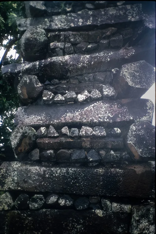
Detail of a wall constructed of columnar basalt pieces at Nan Madol
Detail of a wall constructed of columnar basalt pieces at Nan Madol | Jebrennan (CC BY-SA 4.0)

Discovery and Early Exploration

European accounts of Nan Madol began in the mid-19th century with traders and missionaries. However, the first scientific documentation was by Polish naturalist John Stanislaw Kubary in 1874. German ethnographer Paul Hambruch conducted extensive surveys in the early 20th century, producing the first detailed map. While early visitors speculated about lost civilizations from Egypt or Atlantis, subsequent research firmly attributed the site to indigenous Micronesians.

Archaeological Investigations

Modern excavations started in the 1960s, revealing pottery, shell artifacts, and charred plant remains that shed light on daily life. The most comprehensive campaigns were led by American archaeologist J. Stephen Athens in the 1980s and 1990s, focusing on chronology and subsistence. Later work by William Ayres and others clarified the quarrying methods and social organization. Ongoing geophysical surveys by the Federated States of Micronesia Historic Preservation Office continue to uncover new features without invasive excavation.
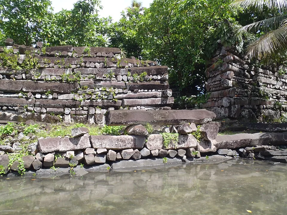
Nan Madol megalithic site, Pohnpei (Federated States of Micronesia) 5
Nan Madol megalithic site, Pohnpei (Federated States of Micronesia) 5 | Patrick Nunn (CC BY-SA 4.0)

Significance and Preservation

Designated a UNESCO World Heritage Site in 2016, Nan Madol is recognized as an outstanding example of megalithic architecture in the Pacific. Its construction reflects the peak of pre-contact Micronesian engineering and socio-political complexity. However, the site faces threats from vegetation overgrowth, storm surges, and rising sea levels. Conservation efforts balance traditional stewardship with modern scientific intervention to prevent further deterioration of this fragile cultural landscape.

Perché è importante

Nan Madol represents the only known fully basalt-built city on the ancient world's coastlines, showcasing advanced engineering and social complexity in Oceania without the use of metal tools or draft animals. It serves as a touchstone for understanding pre-colonial Pacific societies' chiefdom-level governments and long-distance interaction networks. Its enduring oral traditions also provide a rare case study in the intersection of archaeology and indigenous historical narratives.

Evidenze e interpretazione

Distinguere ciò che è ben consolidato da ciò che rimane dibattuto.

Fatti ben consolidati

3
  • Radiocarbon dates from charcoal and shell within the islets bracket construction from the 12th to 16th centuries CE.
  • Geochemical analysis matches the basalt to quarry sites on the main island of Pohnpei, confirming local origin.
  • Oral histories accurately record the overthrow of the Saudeleur, which is consistent with the site’s abandonment around 1628.

Deduzioni accademiche

2
  • The transportation of multi-ton stones likely involved rafts, rollers, and ramps, drawing on experimental archaeology.
  • The hierarchical layout of islets suggests a stratified society with differential access to sacred spaces.

Interpretazioni dibattute

2
  • Scholars contest whether the site was primarily a ceremonial and elite residence or also a dense urban settlement with commoners.
  • There is ongoing discussion about the possible pre-Saudeleur occupation and the degree of continuity with earlier Lapita traditions.

Scoperta e scavo

1874

First scientific documentation

Diretto da John S. Kubary

John Stanislaw Kubary recorded the site’s layout and collected preliminary notes on its construction and oral traditions.

1909–1910

Hambruch’s Thilenius Expedition

Diretto da Paul Hambruch

Comprehensive mapping and photographic survey; first detailed plan of the islets; collected artifacts and oral accounts.

1963–1964

Smithsonian Institution Investigation

Diretto da Byron W. Bender and others

Small-scale test excavations into burial platforms and living areas, recovering pottery and shell middens.

1980–1995

Athens and Ayres Chronology Project

Diretto da J. Stephen Athens and William S. Ayres

Systematic radiocarbon dating and stratigraphic excavation across multiple islets, establishing the main occupation sequence.

2015

UNESCO World Heritage Listing

Diretto da FSM Historic Preservation Office and UNESCO

Conservation-focused assessment and documentation; establishment of management plan and ongoing monitoring.

Foto della comunità

Condividi la tua esperienza

Hai visitato questo sito? Carica le tue foto per aiutare gli altri a scoprirlo.

Come citare questa pagina

Atlas Anatolia. (1200). Nan Madol. Atlas Anatolia. https://atlasanatolia.com/it/site/nan-madol

Contenuto con licenza CC BY-SA 4.0 — è richiesta l'attribuzione in caso di riutilizzo.

Fonti

  • Ayres, W.S. (2014), Nan Madol: The Archaeology of a Pacific ChiefdomWilliam S. Ayres (2014)
  • Athens, J.S. (1990), ‘Nan Madol: A Megalithic Administrative Center’J. Stephen Athens (1990)
  • UNESCO World Heritage entryUNESCOCollegamento
  • Morgan, W.N. (1988), Prehistoric Architecture in MicronesiaWilliam N. Morgan (1988)
  • Rainbird, P. (2004), The Archaeology of MicronesiaPaul Rainbird (2004)

Domande frequenti

Dove si trova Nan Madol?

Nan Madol si trova in Pohnpei, Eastern Caroline Islands, Federated States of Micronesia.

A quando risale Nan Madol?

Nan Madol risale all'incirca al 1200 d.C. – 1628 d.C..

Quali civiltà sono associate a Nan Madol?

Nan Madol è associato alla civiltà Saudeleur.

Perché Nan Madol è importante?

Nan Madol represents the only known fully basalt-built city on the ancient world's coastlines, showcasing advanced engineering and social complexity in Oceania without the use of metal tools or draft animals.

Nan Madol è un sito Patrimonio Mondiale dell'UNESCO?

Sì — Nan Madol è iscritto nella lista del Patrimonio Mondiale dell'UNESCO.