
Skip to content
Atlas AnatoliaAtlas Anatolia
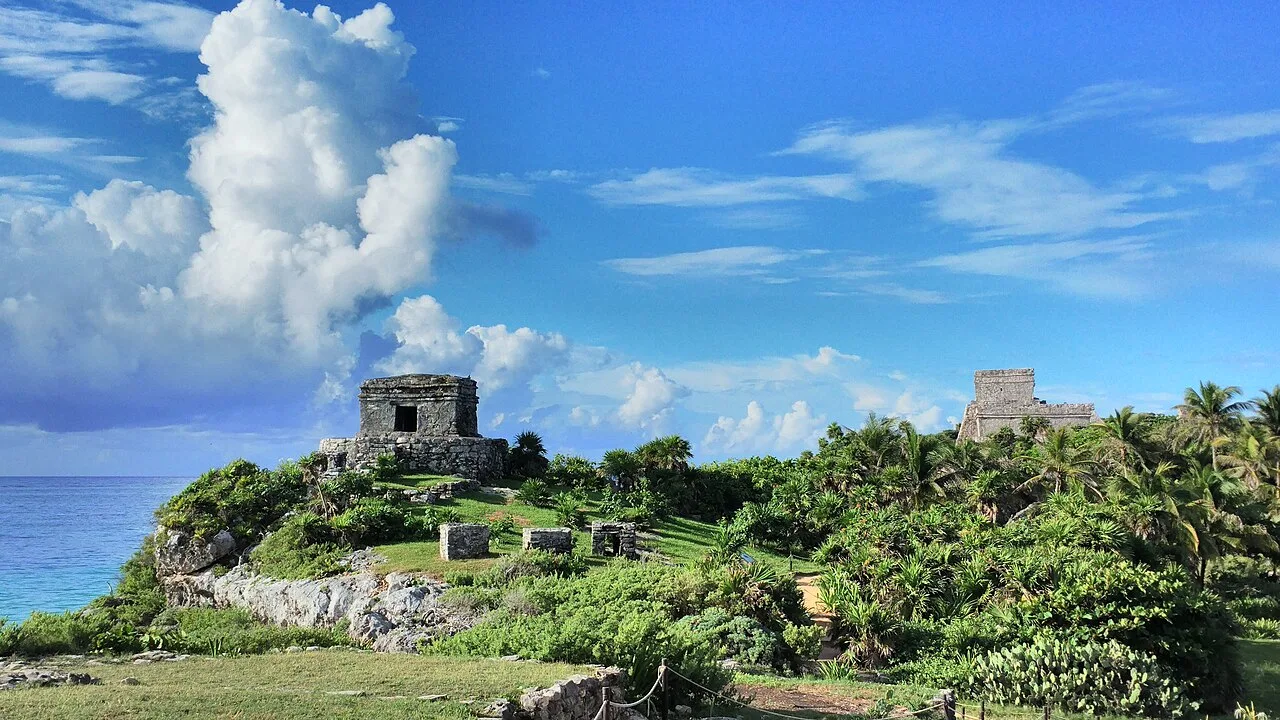
El Castillo at Tulum on a cliff above the Caribbean Sea, Quintana Roo, Mexico

Tulum

Tulu'um1200 CE – 1524 CE
78

Interest

Pre-ColumbianMaya

Peak period

c. 1200–1521 CE (Postclassic Maya)

Defensive wall

3–5 m high, up to 8 m thick, on three landward sides

El Castillo

Clifftop pyramid, ~12 m above the sea; possible navigation beacon

First European sighting

1518 — Juan de Grijalva expedition

Documented

Stephens & Catherwood, 1841

Function

Maritime trading port (obsidian, jade, cacao, salt, copper)

Tulum is one of the best-preserved Maya coastal sites and one of the very few that was still a living, functioning city when Europeans arrived — making it a rare bridge between the pre-Columbian Maya world and the historical record of contact.”

Overview

Tulum sits on the Caribbean coast of Quintana Roo in southeastern Mexico, about 130 kilometres south of Cancún. Its original Maya name may have been Zama, meaning "dawn" or "morning" — appropriate for a city facing east over the sea toward the sunrise; "Tulum," meaning "wall" or "fence" in Yucatec Maya, is a later name describing its most distinctive feature. It was one of the few Maya cities to be enclosed by a defensive wall: a thick limestone rampart, 3 to 5 metres high and up to 8 metres thick, ran around the landward three sides of the settlement, while the cliff and sea protected the fourth.

Unlike the great Classic-period Maya cities of the interior, which had largely collapsed by 900 CE, Tulum belongs to the Postclassic period and reached its height between roughly 1200 and 1521 CE. It functioned as a major node in the maritime and overland trade networks of the Maya world, exchanging goods such as obsidian, jade, cacao, copper, salt, and textiles along the coast and into Central America. The buildings are smaller and more austere than the soaring pyramids of Tikal or Palenque, reflecting both the late date and the city's mercantile rather than monumental-ceremonial character.

The dominant structure is El Castillo ("the castle"), a stepped pyramid built on the very edge of the 12-metre cliff, which may have served as a navigational beacon, guiding canoes through a gap in the offshore barrier reef. Other significant buildings include the Temple of the Frescoes, which preserves murals depicting Maya deities in a distinctive coastal "East Coast" style, and the Temple of the Descending God, named for the inverted winged figure carved above its doorway. The murals and architecture show stylistic links to the Mixteca-Puebla tradition of central Mexico, indicating Tulum's connections far beyond the Maya region.

Tulum was first recorded by Europeans in 1518, when the Spanish expedition of Juan de Grijalva sailed past and the chronicler Juan Díaz compared its size to the city of Seville. The city survived into the colonial period but was eventually abandoned as Old World diseases devastated the indigenous population. It was documented in detail by the explorers John Lloyd Stephens and Frederick Catherwood in 1841, whose published accounts and engravings brought it to international attention.

Why It Matters

Tulum is one of the best-preserved Maya coastal sites and one of the very few that was still a living, functioning city when Europeans arrived — making it a rare bridge between the pre-Columbian Maya world and the historical record of contact. Its survival into the 16th century, documented by Spanish chroniclers, provides a chronological anchor that most Maya sites, abandoned centuries earlier, lack. Archaeologically, the murals of the Temple of the Frescoes are among the most important surviving examples of Postclassic Maya painting, preserving religious iconography and revealing the stylistic exchange between the Maya and the cultures of central Mexico. Its dramatic clifftop setting above the Caribbean has also made it one of the most visited and recognisable archaeological sites in the Americas, a defining image of the Maya world for a global audience.

Stay curious

New stories and sites, once a month. No spam.

Evidence & Interpretation

Distinguishing what is well-established from what remains debated.

Well-Established Facts

3
  • The 1518 sighting by the Grijalva expedition is recorded by the chronicler Juan Díaz, who compared the city in size to Seville — a firsthand European account establishing that Tulum was still inhabited at contact, unlike most Maya cities.
  • The murals of the Temple of the Frescoes survive in situ and depict Maya deities in the "East Coast" style with iconographic links to the central Mexican Mixteca-Puebla tradition, confirmed by stylistic analysis.
  • The defensive wall enclosing the landward sides of the city is intact and is one of the few such fortification walls known from the Maya world, marking Tulum as an unusually defended settlement.

Scholarly Inferences

1
  • El Castillo is thought to have functioned as a navigational marker for canoe traffic: a gap in the offshore reef aligns with the structure, and a beacon there would have guided boats safely to shore. The interpretation is widely accepted but rests on the geographic alignment rather than direct documentary evidence.

Debated Interpretations

1
  • The size of Tulum's permanent population is uncertain. Estimates range from around 1,000 to several thousand residents within the walls, with debate over whether the enclosed area housed the general population or only an elite and ceremonial precinct served by a larger dispersed hinterland.

More Photos

Museum Artifacts

Community Photos

Share your experience

Have you visited this site? Upload your photos to help others discover it.

Location

Sources

  • Incidents of Travel in YucatanStephens, John Lloyd (1843)
  • On the Edge of the Sea: Mural Painting at Tancah-TulumMiller, Arthur G. (1982)

Research Papers