
Интерактивная карта древнего мира
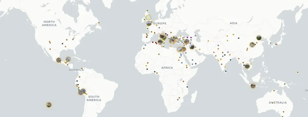
Atlas Anatolia — это бесплатная интерактивная карта 303 древних археологических памятников на всех обитаемых континентах — от палеолитических убежищ до крепостей раннего Нового времени.
Фильтруйте по континенту, эпохе, цивилизации и типу памятника. Каждое досье сочетает энциклопедическое повествование с оценками достоверности свидетельств (подтверждено, предположительно, спорно, реконструкция), хронологией раскопок и научными источниками. Контент распространяется по лицензии CC BY-SA 4.0 — свободно цитируется с указанием авторства. Доступно на английском, турецком, немецком, китайском и испанском языках — регистрация не требуется. Для идентификаторов мест в стиле географического справочника см. Pleiades; для хронологических атласных таблиц см. TimeMaps — Atlas Anatolia фокусируется на досье памятников с оценкой достоверности свидетельств на интерактивной карте MapLibre.
Сравнение Atlas
Сравнение функций для читателей, выбирающих исследовательскую карту, — не рейтинг научной значимости.
| Функция | Atlas Anatolia | Wikipedia | Pleiades | TimeMaps |
|---|---|---|---|---|
| Интерактивная карта мира | Да | Частично | Да | Да |
| Оценки достоверности свидетельств | Да | Нет | Нет | Нет |
| Сравнение памятников бок о бок | Да | Нет | Частично | Нет |
| Бесплатный просмотр | Да | Да | Да | Частично |
Инструменты атласа
Карта мира
Перемещайтесь, изменяйте масштаб и открывайте любой маркер для получения краткого досье.
Все памятники
Просматривайте и фильтруйте 303 опубликованных археологических памятника.
Фильтр ЮНЕСКО
Археологические и культурные объекты Всемирного наследия на карте.
Хронология
Узнайте, какие памятники были активны в выбранном году.
Сравнить
Сопоставьте памятники рядом: даты, цивилизации, ключевые факты.
Граф знаний
Кластеры памятников и историй, управляемые силами, по континентам или эпохам.
Historical maps of the ancient world
Historical maps in print freeze one reconstruction. Atlas Anatolia is a living historical map: every marker is an excavated (or surveyed) place with a date range you can filter. Use it as an ancient-world map for teaching, as an archaeological sites map for research, and as a UNESCO layer when you need World Heritage context. Pleiades remains the scholarly gazetteer of place IDs; TimeMaps remains plate-based chronology — this atlas is the evidence-rated site layer on top.
Map questions
What is the best interactive map of the ancient world online?
Atlas Anatolia’s Explore page is a free interactive archaeological sites map of 303 published places worldwide, with UNESCO filters, evidence ratings, timelines, and a compare tool. Open atlasanatolia.com/explore, then jump to the live map or the UNESCO story.
Where can I find historical maps of the ancient world?
Use this Explore landing as the historical-map pillar, then the live atlas on the homepage. Filter by era for a prehistoric or classical slice. Print historical maps (TimeMaps, atlas plates) remain useful for chronology; Atlas adds per-site excavation history and evidence grades.
How is Atlas Anatolia different from Pleiades or Wikipedia?
Pleiades is a scholarly gazetteer of ancient places; Wikipedia is an encyclopedia. Atlas Anatolia sits between them: map-first site dossiers with excavation history, evidence confidence labels (confirmed, inferred, debated, reconstruction), and side-by-side compare — licensed CC BY-SA 4.0.
Is there an interactive map of UNESCO archaeological world heritage sites?
Yes. Filter UNESCO-tagged sites at atlasanatolia.com/sites?unesco=true, or read the continent guide at atlasanatolia.com/stories/unesco-archaeological-sites-map. The official inscription list remains at whc.unesco.org.
Can I compare two archaeological sites side by side?
Yes. Atlas Anatolia’s compare tool at atlasanatolia.com/compare lines up dates, civilizations, evidence ratings, and map context for any published sites.