
प्राचीन विश्व का इंटरएक्टिव मानचित्र
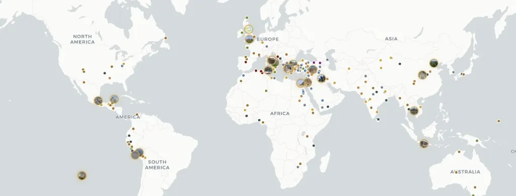
एटलस अनातोलिया सभी बसे हुए महाद्वीपों में फैले 303 प्राचीन पुरातात्विक स्थलों का एक मुफ़्त इंटरएक्टिव मानचित्र है — पुरापाषाण कालीन आश्रयों से लेकर आधुनिक युग के आरंभिक क़िलों तक।
महाद्वीप, काल, सभ्यता और स्थल प्रकार के आधार पर फ़िल्टर करें। प्रत्येक डोजियर विश्वकोशीय विवरण को साक्ष्य विश्वसनीयता रेटिंग (पुष्ट, अनुमानित, विवादित, पुनर्निर्माण), उत्खनन समय-सारणी और विद्वतापूर्ण स्रोतों के साथ जोड़ता है। सामग्री CC BY-SA 4.0 है — श्रेय के साथ उद्धृत करने के लिए स्वतंत्र। अंग्रेज़ी, तुर्की, जर्मन, चीनी और स्पेनिश में उपलब्ध — किसी खाते की आवश्यकता नहीं। गजेटियर-शैली स्थान आईडी के लिए Pleiades देखें; कालानुक्रमिक एटलस प्लेटों के लिए TimeMaps देखें — Atlas Anatolia एक इंटरैक्टिव MapLibre मानचित्र पर साक्ष्य-रेटेड स्थल डोजियर पर केंद्रित है।
Atlas की तुलना कैसे करें
शोध मानचित्र चुनने वाले पाठकों के लिए सुविधा तुलना — विद्वत्ता की रैंकिंग नहीं।
| विशेषता | Atlas Anatolia | Wikipedia | Pleiades | TimeMaps |
|---|---|---|---|---|
| इंटरैक्टिव विश्व मानचित्र | हाँ | आंशिक | हाँ | हाँ |
| साक्ष्य विश्वसनीयता रेटिंग | हाँ | नहीं | नहीं | नहीं |
| साथ-साथ स्थल तुलना | हाँ | नहीं | आंशिक | नहीं |
| निःशुल्क ब्राउज़ करें | हाँ | हाँ | हाँ | आंशिक |
एटलस पर उपकरण
विश्व मानचित्र
पैन करें, ज़ूम करें, और किसी भी मार्कर को संक्षिप्त डोजियर के लिए खोलें।
सभी स्थल
303 प्रकाशित पुरातात्विक स्थलों को ब्राउज़ और फ़िल्टर करें।
यूनेस्को फ़िल्टर
मानचित्र पर विश्व धरोहर पुरातात्विक और सांस्कृतिक स्थल।
समयरेखा
देखें कि चुने हुए वर्ष में कौन से स्थल सक्रिय थे।
तुलना करें
स्थलों को साथ-साथ रखें — तिथियाँ, सभ्यताएँ, मुख्य तथ्य।
ज्ञान ग्राफ़
महाद्वीप या युग के अनुसार स्थलों और कहानियों के बल-निर्देशित समूह।
Historical maps of the ancient world
Historical maps in print freeze one reconstruction. Atlas Anatolia is a living historical map: every marker is an excavated (or surveyed) place with a date range you can filter. Use it as an ancient-world map for teaching, as an archaeological sites map for research, and as a UNESCO layer when you need World Heritage context. Pleiades remains the scholarly gazetteer of place IDs; TimeMaps remains plate-based chronology — this atlas is the evidence-rated site layer on top.
Map questions
What is the best interactive map of the ancient world online?
Atlas Anatolia’s Explore page is a free interactive archaeological sites map of 303 published places worldwide, with UNESCO filters, evidence ratings, timelines, and a compare tool. Open atlasanatolia.com/explore, then jump to the live map or the UNESCO story.
Where can I find historical maps of the ancient world?
Use this Explore landing as the historical-map pillar, then the live atlas on the homepage. Filter by era for a prehistoric or classical slice. Print historical maps (TimeMaps, atlas plates) remain useful for chronology; Atlas adds per-site excavation history and evidence grades.
How is Atlas Anatolia different from Pleiades or Wikipedia?
Pleiades is a scholarly gazetteer of ancient places; Wikipedia is an encyclopedia. Atlas Anatolia sits between them: map-first site dossiers with excavation history, evidence confidence labels (confirmed, inferred, debated, reconstruction), and side-by-side compare — licensed CC BY-SA 4.0.
Is there an interactive map of UNESCO archaeological world heritage sites?
Yes. Filter UNESCO-tagged sites at atlasanatolia.com/sites?unesco=true, or read the continent guide at atlasanatolia.com/stories/unesco-archaeological-sites-map. The official inscription list remains at whc.unesco.org.
Can I compare two archaeological sites side by side?
Yes. Atlas Anatolia’s compare tool at atlasanatolia.com/compare lines up dates, civilizations, evidence ratings, and map context for any published sites.