
خريطة تفاعلية للعالم القديم
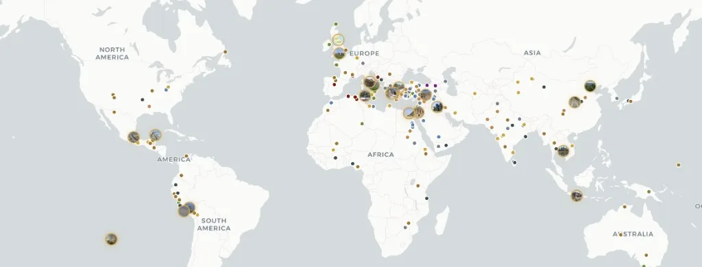
أطلس الأناضول هو خريطة تفاعلية مجانية تضم 303 موقعًا أثريًا قديمًا في كل القارات المأهولة — من الملاجئ الحجرية القديمة إلى حصون العصر الحديث المبكر.
تصفية حسب القارة والعصر والحضارة ونوع الموقع. يجمع كل ملف بين السرد الموسوعي وتقييمات موثوقية الأدلة (مؤكد، مستنتج، متنازع عليه، إعادة بناء)، والجداول الزمنية للحفريات، والمصادر الأكاديمية. المحتوى مرخص بموجب CC BY-SA 4.0 — حر الاستشهاد به مع الإسناد. متوفر باللغات الإنجليزية والتركية والألمانية والصينية والإسبانية — لا يتطلب حسابًا. لمعرفات الأماكن بأسلوب المعجم الجغرافي انظر Pleiades؛ وللألواح الزمنية الأطلسية انظر TimeMaps — يركز أطلس الأناضول على ملفات المواقع ذات الأدلة المقيمة على خريطة تفاعلية MapLibre.
كيف يقارن أطلس
مقارنة الميزات للقراء الذين يختارون خريطة بحثية — وليس تصنيفًا للمنح الدراسية.
| الميزة | Atlas Anatolia | Wikipedia | Pleiades | TimeMaps |
|---|---|---|---|---|
| خريطة تفاعلية للعالم | نعم | جزئي | نعم | نعم |
| تقييمات موثوقية الأدلة | نعم | لا | لا | لا |
| مقارنة المواقع جنبًا إلى جنب | نعم | لا | جزئي | لا |
| مجاني للتصفح | نعم | نعم | نعم | جزئي |
أدوات الأطلس
خريطة العالم
تحريك، تكبير، وفتح أي علامة للحصول على ملف موجز.
جميع المواقع
تصفح وتصفية 303 موقعًا أثريًا منشورًا.
تصفية اليونسكو
المواقع الأثرية والثقافية للتراث العالمي على الخريطة.
الخط الزمني
اكتشف المواقع التي كانت نشطة في سنة مختارة.
مقارنة
قارن المواقع جنبًا إلى جنب: التواريخ، الحضارات، الحقائق الأساسية.
الرسم البياني المعرفي
مجموعات من المواقع والقصص مرتبة بقوى حسب القارة أو العصر.
Historical maps of the ancient world
Historical maps in print freeze one reconstruction. Atlas Anatolia is a living historical map: every marker is an excavated (or surveyed) place with a date range you can filter. Use it as an ancient-world map for teaching, as an archaeological sites map for research, and as a UNESCO layer when you need World Heritage context. Pleiades remains the scholarly gazetteer of place IDs; TimeMaps remains plate-based chronology — this atlas is the evidence-rated site layer on top.
Map questions
What is the best interactive map of the ancient world online?
Atlas Anatolia’s Explore page is a free interactive archaeological sites map of 303 published places worldwide, with UNESCO filters, evidence ratings, timelines, and a compare tool. Open atlasanatolia.com/explore, then jump to the live map or the UNESCO story.
Where can I find historical maps of the ancient world?
Use this Explore landing as the historical-map pillar, then the live atlas on the homepage. Filter by era for a prehistoric or classical slice. Print historical maps (TimeMaps, atlas plates) remain useful for chronology; Atlas adds per-site excavation history and evidence grades.
How is Atlas Anatolia different from Pleiades or Wikipedia?
Pleiades is a scholarly gazetteer of ancient places; Wikipedia is an encyclopedia. Atlas Anatolia sits between them: map-first site dossiers with excavation history, evidence confidence labels (confirmed, inferred, debated, reconstruction), and side-by-side compare — licensed CC BY-SA 4.0.
Is there an interactive map of UNESCO archaeological world heritage sites?
Yes. Filter UNESCO-tagged sites at atlasanatolia.com/sites?unesco=true, or read the continent guide at atlasanatolia.com/stories/unesco-archaeological-sites-map. The official inscription list remains at whc.unesco.org.
Can I compare two archaeological sites side by side?
Yes. Atlas Anatolia’s compare tool at atlasanatolia.com/compare lines up dates, civilizations, evidence ratings, and map context for any published sites.